Seattle Public Transportation Guide for Tourists
Seattle public transportation is easiest with ORCA and the Link light rail. Use buses, streetcars, and the monorail for quick tourist hops. Take the ferry when you want the skyline view. eSIM USA travel keeps maps and arrivals working.
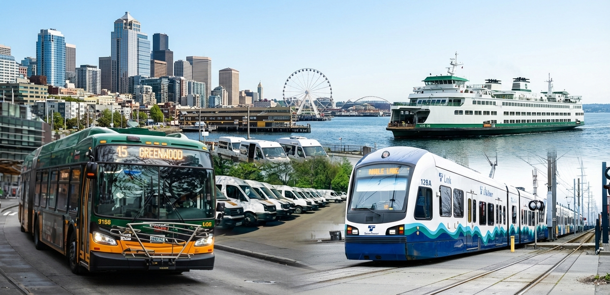
Visiting Seattle is an adventure made easier by its robust transit network. In Seattle, Washington, public transportation includes an array of options – from sleek light rail trains and frequent buses to historic monorails and scenic ferries. Navigating the Emerald City without a car is not only possible, but it’s also often enjoyable.
In fact, public transit can be the best way to get around Seattle, offering a chance to sightsee and avoid traffic and parking hassles. This comprehensive travel guide will walk you through everything you need to know about Seattle public transportation, from the types of transport available to fares, passes, and tips for tourists. Whether you’re an international visitor or a domestic traveler, Seattle’s transit system can connect you to nearly every corner of the city.
The Seattle public transportation system is interconnected by the ORCA card (One Regional Card for All) for seamless transfers, and it reaches most major attractions.
Read on for a complete guide to Seattle local transportation – it covers light rail, buses, ferries, streetcars, monorail, and staying connected with mobile data (including eSIM options for the USA). Let’s jetset in!
Types of Public Transportation in Seattle
Seattle public transportation has several transit options, each useful for different trips. Here’s what to know so you can choose the best way to get around.
#1. Link Light Rail (Sound Transit)
Link light rail (the 1 Line) is a fast, reliable train connecting key areas. It runs from Sea-Tac Airport through downtown Seattle and up to Northgate, stopping at hubs like SoDo, Pioneer Square, Westlake, Capitol Hill, and the University of Washington.
- Airport to downtown: about 37 minutes to Westlake Station
- Frequency: usually every 6 to 15 minutes (varies by time of day)
- Tourist-friendly: luggage racks, clear signage, easy navigation
- How to pay: tap an ORCA card or buy a ticket before boarding
- Typical hours: early morning (around 5 AM) to late night (around midnight)
- Example: Westlake to UW is roughly 10 minutes
#2. King County Metro Buses
Metro buses cover the areas trains don’t and are often the easiest way to reach neighborhoods like Fremont, Ballard, and Alki Beach.
- Many routes run every 10 to 15 minutes during the day
- Some routes run later, plus limited Night Owl service after midnight
- RapidRide lines (like D and E) come more often and make fewer stops
- How to pay: tap ORCA when boarding, or pay exact cash at the farebox
- Example: RapidRide D Line connects downtown to Ballard via Seattle Center
Tip: pull the stop cord about a block or two before your stop
#3. Seattle Streetcar
Seattle has two streetcar lines that work well for short trips in specific areas.
- South Lake Union Streetcar: Westlake to South Lake Union
- First Hill Streetcar: Pioneer Square and International District to Capitol Hill via First Hill
- Runs about every 10 to 15 minutes
- Fare: same as bus/light rail (as of 2025, $3.00 adult)
- How to pay: tap ORCA at the platform or buy a paper ticket at the kiosk
#4. Seattle Center Monorail
The Monorail is a quick, classic ride between downtown and Seattle Center.
- Runs from Westlake Center (inside the mall, 3rd floor) to Seattle Center near the Space Needle
- Ride time: about 2 minutes
- Frequency: about every 10 minutes
- Adult fare: $3.00 (youth 18 and under free, seniors/disabled $1.50)
- Payment: ORCA tap or buy a ticket with a card at the machine
- ORCA transfers can count toward the monorail fare within the transfer window
#5. Ferries and Water Taxis
Ferries are a Seattle highlight and double as a scenic way to travel.
Washington State Ferries (from Pier 52)
- Bainbridge Island: about 35 minutes each way, great skyline views
- Bremerton: about 60 minutes each way
- Walk-on tickets are typically about $9 to $10 round-trip, and you usually pay for leaving Seattle (no charge returning for walk-ons)
- No reservations needed for walk-on passengers
#6. King County Water Taxi (from Pier 50)
- Downtown to West Seattle (Seacrest dock): about 10 minutes
- Good for visiting Alki Beach and skyline views
- Seasonal shuttle service often connects riders to Alki in the summer
- Limited service also runs to Vashon Island
ORCA is accepted on water taxis and many services, but ORCA day passes do not cover Washington State Ferries, so ferry fares are typically separate.
Fares and Passes: How to Pay
#1. ORCA card basics
ORCA (One Regional Card for All) works across buses, light rail, streetcars, monorail, water taxis, and more. It’s the easiest option if you’ll take multiple rides.
- Card cost: $3.00
- Where to buy: vending machines at Link stations (including Sea-Tac), and other major locations
- Load stored value (“E-purse”) or passes, then tap the yellow reader when boarding or entering
Adult fares (typical city sightseeing)
- Standard adult fare is around $2.75 to $3.00 per ride
- As of 2025, many core rides are $3.00 (Metro buses, Link light rail, streetcar, monorail)
- Ferries and some premium services cost more
Transfers
- ORCA includes transfer credit for up to 2 hours (generally one direction) across agencies
- You usually won’t pay again if the next ride is the same fare or cheaper
- Cash on Metro buses does not provide transfers to other services
ORCA Day Pass
If you plan to ride a lot in one day:
- $6.00 day pass covers unlimited rides up to $3.00 per trip on most Seattle-area transit
- If a ride costs more than $3, you pay the difference
- Not valid for Washington State Ferries
Other options
- Ticket machines at Link and streetcar stations sell single tickets
- Metro buses take exact cash
- The Transit GO Ticket app sells mobile tickets for some services, but ORCA is usually simpler and better value if you’re taking multiple trips
Pro tip: Buy an ORCA card at the Sea-Tac Airport Link station and load a $6 day pass or stored value. It covers your ride into town and makes transfers much easier.
Navigating Seattle’s Transit Like a Pro
Now that you know what to ride, here are practical tips to use Seattle public tranportation for transit confidently as a tourist.
Planning trips
Use Google Maps or Apple Maps, or apps like Transit and OneBusAway for real-time arrivals and step-by-step directions. King County Metro also has a trip planner. Service is generally reliable, but build in extra time for tighter connections, especially for ferries and the monorail, since they run less often than buses and trains.
At the station or stop
- Link light rail: Stations are well signed. From Sea-Tac, follow signs for light rail (often marked “Trains to City”). Downtown stations like Westlake, University Street, and Pioneer Square are underground, so look for entrances with the Link logo.
- Buses: Stops show route numbers. Downtown, especially along 3rd Avenue, multiple routes share stops, and electronic signs usually show arrival times. Queue up, let riders exit first, then board.
- Streetcars: Wait on the platform. Tap ORCA or have your ticket ready before boarding.
On board
- Link and streetcars: Sit anywhere. Fare checks can happen, so keep your ticket or ORCA ready.
- Buses: Board at the front unless told otherwise. Tap ORCA near the driver or pay with exact cash. Stops are usually announced, but it helps to follow along on your maps app. Pull the stop cord about a block before your stop.
Safety and etiquette
Seattle transit is generally safe and well-lit, and main routes still have riders in the evening. Keep normal precautions: secure your bag and stay aware. You may see fare inspectors on Link or security near major hubs like Westlake.
Good local habits:
- Stand to the right on escalators if you’re not walking
- Offer priority seating to those who need it
- Keep calls quiet and backpacks out of the aisle
- With luggage, keep bags clear of doors and walkways
If you’re unsure, ask a driver or nearby rider; people are usually helpful.
Accessibility
All major transit options are accessible:
- Buses kneel and have ramps
- Light rail stations have elevators and level boarding
- Streetcars and the monorail are wheelchair accessible
Look for accessibility symbols and priority seating areas.
Late nights
If you’re out late, plan ahead:
- Link typically stops around 12:30 AM (about 1 AM on weekends)
- Streetcars usually wrap up by 11 PM
- Many bus routes end by midnight, but some Night Owl routes run overnight (limited coverage).
If you miss the last trip, rideshare or taxis can be the simplest backup. Once you’ve done a couple of rides, Seattle transit feels straightforward.
Bonus: You’ll see more of the city’s neighborhoods and everyday life than you would from a car.
Public Transit to Major Seattle Attractions
Want to reach a specific sight? Here’s a quick guide to the top attractions and how to get there without a car.
#1. Space Needle and Seattle Center
Take the Seattle Center Monorail from Westlake Center (downtown) straight to Seattle Center. You can also use buses like RapidRide D Line or routes 3/4. Light rail does not go directly, but you can take the Link to Westlake and transfer to the Monorail or a bus. Nearby spots include MoPOP, Chihuly Garden, Pacific Science Center, and Climate Pledge Arena.
#2. Pike Place Market
From Westlake Station, it’s an easy 5 to 10 minute walk to 1st and Pike. Many buses stop nearby on 3rd Ave or 1st Ave.
#3. Seattle Waterfront and Aquarium
From downtown or Pike Place, walk downhill toward Elliott Bay. Many buses stop near 1st Ave and Pioneer Square, and it’s a short walk to the piers. The ferry terminal (Pier 52) is also near Pioneer Square. Take the Link to Pioneer Square Station and walk about 5 minutes.
#4. Sports Stadiums (Lumen Field and T-Mobile Park)
Take the Link light rail to Stadium Station or International District/Chinatown Station. From Westlake to Stadium Station is about 10 minutes, then a short walk to the gates. Extra trains often run on game days, and many buses also serve this area.
#5. Seattle Art Museum (SAM)
SAM is at 1st Ave and University St. It’s about a 3-block walk from Westlake Station or most downtown bus stops.
#6. Seattle Center Museums and Woodland Park Zoo
Seattle Center museums (like Chihuly and MoPOP) are easiest via the Monorail or buses. For Woodland Park Zoo, take Metro bus route 5 from downtown (around 20 minutes). Routes 44 and 62 also serve the zoo area.
#7. University of Washington and Husky Stadium
Take the Link to the University of Washington Station for Husky Stadium and nearby campus access. U District Station (one stop north) puts you closer to the University District and “The Ave” (University Way NE). Light rail is especially useful on game days to avoid Montlake traffic.
#8. Capitol Hill and Volunteer Park
Take the Link to Capitol Hill Station for Broadway and Pike/Pine. From there, it’s about a 15-minute walk to Volunteer Park, or a quick ride on Route 10. Capitol Hill is also well-served by buses like 10, 11, and 49.
Most major Seattle attractions are easy to reach by transit, especially around downtown. If you’re unsure, plug your destination into a mapping app and choose the best bus or train route.
Sample Transit Itineraries for Tourists
Here are a few example itineraries showing how you can use Seattle public transportation, transit for sightseeing.
1) Airport to Downtown and Seattle Center
After landing at Sea-Tac, follow the signs to the Link light rail station and take the train toward Northgate. Ride about 37 minutes to Westlake Station in downtown.
From Westlake, you have two easy options:
- Explore downtown on foot: Westlake Park and Pike Place Market are a short walk.
- Go straight to the Space Needle: head into Westlake Center, go to the third floor, and take the Seattle Center Monorail. It’s a quick ride to Seattle Center.
Spend time at the Space Needle, MoPOP, or Chihuly Garden, then take the Monorail back downtown. This light rail + monorail combo is one of the simplest ways for first-timers to hit major sights.
2) Downtown, Pioneer Square, Ferry, and the Waterfront
Start at Pike Place Market (walk or take a quick bus from most downtown hotels). After the market, take a bus south on 1st Ave or 3rd Ave to Pioneer Square (some routes include Metro 62, and there’s a free waterfront shuttle in summer).
In Pioneer Square, explore the neighborhood, then walk to the Washington State Ferry Terminal (Pier 52). Take a midday ferry to Bainbridge Island for the skyline views on the roughly 30-minute ride. On Bainbridge, stroll Winslow near the terminal, then return on the next ferry. Round-trip is about $10, paid in Seattle (no charge on the return).
Back in Seattle, walk along the waterfront to the Seattle Aquarium and the Great Wheel (Pier 57). When you’re ready, head up to 3rd Ave for buses, or take the Link from Pioneer Square Station back to your hotel.
3) University District and Capitol Hill
Start downtown at Westlake (or any Link station) and take the Link north to the U District Station (about 8 minutes). Visit the University of Washington area, plus museums like the Burke Museum or Henry Art Gallery (and cherry blossoms in spring).
Then hop back on Link and ride to Capitol Hill Station (a short ride from the U District). The station puts you right on Broadway, one of the city’s best areas for food, coffee, and nightlife. For the return, take Link, or buses like 10 or 49, or walk downhill if you feel like it.
These are just starting points. You can mix light rail, buses, the ferry, and the monorail to build your own plan since most major Seattle sights are well connected by transit.
Staying Connected on the Go: Mobile Data and eSIM Options
Exploring Seattle is much easier with mobile internet for maps, transit apps, and staying in touch. If you’re visiting from abroad, or you just need better data, a USA travel eSIM can be a simple alternative to roaming. An eSIM is a digital SIM you activate on your phone without swapping a physical card, so you can get data as soon as you land.
One option is Jetpac, which offers travel eSIM plans for the U.S. and other countries. With a Jetpac eSIM, you can set up a U.S. data plan quickly and stay connected without hunting for SIM shops or relying on public Wi-Fi.
Bonus: If your flight is delayed over 1 hour, you can get lounge access at select airports (even some small data packs qualify).
How to use an eSIM?
- Confirm your phone is unlocked and eSIM-compatible
- Buy a plan online (app or website)
- Install via QR code or in-app setup
- Turn it on when you arrive, and use it for maps, transit apps, rideshare, and messaging
An eSIM keeps your trip smoother, especially when you’re navigating bus stops, checking real-time arrivals, or finding your way around neighborhoods.
FAQs
How is the public transportation in Seattle?
Public transportation in Seattle is tourist-friendly once you learn ORCA and Link. The Seattle public transportation system includes light rail, buses, streetcar, monorail, and ferries, so you can reach most major attractions without a car.
Does Seattle have subways?
Seattle does not have a large heavy rail subway system like New York. Link light rail runs underground in parts of downtown, but it is primarily a light rail network.
Does Seattle have good public transportation?
Yes, especially in the main tourist areas. Seattle public transportation is strongest around downtown, Capitol Hill, the University of Washington area, Seattle Center, and the airport corridor. For farther neighborhoods, buses usually fill the gaps.
What is the best way to get around Seattle without a car?
For most visitors, the best way to get around Seattle is a mix of Link light rail for longer trips and walking for short distances. Add buses for neighborhoods and the monorail for Seattle Center days.
How do tourists pay for Seattle public transportation?
Use an ORCA card and consider the ORCA regional day pass. It costs $6 for adult fares up to $3 and runs until 3 am the next day.
Is Seattle, Washington, public transportation easy from the airport?
Yes. The Link light rail connects the SEA Airport to the city, and the adult fare is a flat $3.
How is the public transportation in Seattle?
Public transportation in Seattle is tourist-friendly once you learn the basics. Seattle’s network includes buses, Link light rail, and ferries, run by multiple regional agencies that work together.
Does Seattle have subways?
Seattle does not have a classic heavy rail subway like New York. The light rail runs through a downtown transit tunnel with underground stations, so parts of the ride feel like a subway.
Does Seattle have good public transportation?
Yes, especially if you stay near Link stations or frequent bus routes. For most tourist areas, the Seattle public transportation system makes it easy to get around without a car.
Disclaimer
This content is for educational purposes only and is based on publicly available information. Fares, schedules, pass rules, and service coverage can change. Always verify the latest details with official transit and ferry providers before you travel. Connectivity and eSIM references are informational and not an endorsement.